ARIZONA HANG GLIDING AND PARAGLIDING ASSOCIATION

APACHE MAID
Overview
Apache Main Mountain is one of the premiere northern Arizona flying sites, known especially for its late afternoon/evening glass off/magic air. It is one of the most beautiful flying locations as it sits in gorgeous ponderosa pine forest interspersed with green meadows and pastureland and in the distance to the west, the red rocks of Sedona. When temperatures are in the 100s in Phoenix or Tucson, it is often in the 70s or low 80s at Apache Maid, and a welcome relief that makes the drive worth it. The Apache Maid sunset is hard to beat, and makes the trip worth it even if it is blown out for flying. Apache Maid is not a USHPA/RRRG insured site.
Membership & Waivers: AZHPA membership/AZHPA &Phoenix Parks & Recreation liability waivers
Rating: H3/P2
Location
> Apache Maid Mountain, Coconino National Forest
> HG/PG launch: 34.7231°, -111.5522°
> Designated LZ: 34.7195°, -111.5596°
Airspace Chart
Sedona-Flagstaff-Prescott Area Sectional Chart
Wind Speeds:
HG: Min = 7 mph, Ideal = 12 mph, Max = 20 mph
PG: Min = 5 mph, Ideal = 8-10 mph, Max = 15 mph
Gust Differential:
HG: 5 mph in 5 seconds
PG: 5 mph in 3 seconds
Flyable Wind Direction: Ok = WSW, SSW Ideal = SW
Hazards:
> Gradually sloping grassy launch with few hazards
> Some small rocks and bushes can snag lines
> Agave plants near bottom of launch have extremely sharp tips that can puncture wings
> In winds over 10 - 12 mph possibility of getting plucked prior to turning
> Cross wind launches more than 45 degrees/gusty conditions present real danger
> Be mindful of being blow over back or side, gauging wind speed, direction, ground speed
> LZ: Grass can cover large rocks and boulders
> LZ: Wet Beaver Creek Canyon very deep and steep. Do not land in or near.
Special Instructions:
> P2 pilots not allowed to fly mid-day
> Flagstaff Pulliam Airport (Class D) approx 30 miles to north. Surface to 9,500' ASL
> Have current sectional map

Additional Info
-
Site Frequency: 151.505 Mhz, DCS code 25: Please note you must turn your DCS on, set the code to 25, and make sure it is turned on for both transmit and receive prior to arrival. Programming instructions for most popular 2 meter radios can be found here.
-
Emergencies: Follow the AZPHA General Emergency Action Plan or Apache Maid Emergency Action Plan
Latest REV: 2.8.23
-
All pilots must be current members of the Arizona Hang Gliding and Paragliding Association (AZHPA). Membership info here.
-
All pilots must be current members of the United States Hang Gliding and Paragliding Association (USHPA) and have ratings listed below.
-
All pilots must have a current H3/P2 or higher USHPA rating while launching and flying. P2 pilots must be accompanied by a local P3 or higher rated local pilot familiar with the site. Email flyazh@azhpa.org or reach out on the GroupMe app ahead of time and we will get you dialed in with one. P2 pilots are not allowed to fly mid-day at this site.
-
On-site briefings from a local, qualified pilot are a requirement. This sponsor shall be a qualified pilot that has experience flying that individual site. (See above regarding contacting the club.)
-
Visiting pilots can obtain a visiting pilot pass here and show the registration confirmation as proof.
-
"HA" (high altitude) and "TUR" (turbulence) special skill endorsements are required.
Flagstaff Pulliam Airport (Class D) is the closest airspace, approximately 30 miles to the north. Surface to 9,500 feet ASL. If flying XC please have access to a current sectional map. Sedona-Flagstaff-Prescott Area Sectional Chart (SkyVector.com)
-
All Coconino National Forest Guidelines must be adhered to.
-
Do not launch anywhere except for the designated launching area. (See Images Below)
-
Do not land anywhere except for in the designated landing areas. (See Images Below)
-
Drive carefully on forest service roads, after leaving the paved Stoneman Lake Rd. Deep ruts and exposed rocks are sometimes a hazard depending on time of year and recent weather conditions.
-
Do not land on private property (fenced horse and cattle areas) to the southeast of launch.
-
Do not venture off forest service roads.
Location: Apache Maid Mountain. Launch 34.7231°, -111.5522°, LZ 34.7195°, -111.5596°
Usage: Hang Gliding and Paragliding.
Season: Allowed usage year round but access road gate is locked at first snow in November or December and not opened until March or April.
Affiliation: Arizona Hang Gliding and Paragliding Association. Not a USHPA RRRG insured site.
Land ownership: Coconino National Forest. Two private parcels (see image). County line bisects the mountain (Yavapai east, Coconino west).
Other use: Open to the public for sightseeing, hunting, camping, hiking, ATVs and more.
Orientation of Launch: 7,073' MSL. (2,156m)
Type: 20 degree grassy slope, some small trees and bushes in area out front.
GPS Coordinates Launch: 34.7231°, -111.5522° Google Maps
Winds: Moderate surface winds are preferred. A minimum base wind of 5 mph is needed. WSW, SW, SSW (see above). HG 5-15 mph. PG 5-15 mph. Gust differential 5 mph in 5 seconds.
Driving Directions: From I-17 take Stoneman Lake Rd. (Exit 306) and head east for 6.35 miles until paved road turns into dirt. Right afterwards the road will "T" and you make a right. Follow Forest Service Rd. 83 for approximately nine miles to Maid Trail. Make right. Follow Maid Trail approximately 4 miles to Launch. Google Maps and other GPS apps recognize "Apache Maid Mountain" as a destination.
Road Conditions: High clearance vehicle is helpful, but not mandatory when road has not been rutted or muddied by wet weather (snow or rain). Ask a club member about road conditions before driving out. Once you leave the paved portion of Stoneman Lake Rd., expect to be on forest service roads for thirty minutes to launch
Parking: On the road adjacent to launch there is space for approximately seven or eight cars. Do not block access up or down the mountain when parking along road. There is parking for many vehicles at the base of the road up the mountain (on right before going up, adjacent to the forest service informational sign). Pilots often camp here and shuttle up in a minimal amount of vehicles.
Facilities: None.
Set-up Area PG: Ample set up area well behind and to the north of launch.
Set-up Area HG: Ample set up area well behind and to the north of launch. HG launch is below and to right of PG launch. Seldom used. Ask ahead if you are visiting HG pilot.
Launching: A gradually sloping and grassy launch with a few hazards. 1. Some small rocks and small bushes and twigs can catch lines. 2. Century (agave) plants near the bottom of launch have extremely sharp tips that can puncture wings. 3. In winds over 10 or 12 mph the possibility of getting plucked/pulled off your feet prior to turning increases. Fly your wing and navigate straight out before worrying about getting into your harness or making any adjustments. Pilots have been known to fly into some of the trees on and below launch in these conditions. 4. Light wind launches are not recommended due to the slope and the thick brush below launch. 5. Cross wind launches more than 45 degrees and/or gusty conditions present a real danger at Apache Maid and are not to be attempted
The ridge faces the southwest and is just under 1,000 feet above the flats below. Please understand and follow ridge soaring rules: Pilot closest to the ridge has the right of way. Pilot below has right of way. If two pilots are converging, each should turn right. Do no "pin" a pilot against the ridge leaving him or her no room to turn away. If you are losing ridge lift, it is best to go land and get a ride back up for another chance. Do not scratch close to the hill..
There are three main types of flying at Apache Maid: ridge soaring only (when no thermal or glass off lift is available), thermic flying with XC possibilities, and evening glass off. Evening ridge soaring and glass off flying here is known for having strong thermal mix with base winds. Be aware of this and take at least 30 minutes before launching to assure the gusts and cycles are within your operating conditions. Timing your launch in the late afternoon can give you a few last thermals to 10 or 12k, before it melts into smooth glass off conditions until dark. Cooler air drains into the Beaver Creek Canyon, the forest and the gullies as the sun gets low, and wedges under the warm air, proving glass offs sometimes as high as 12k feet ASL.
On good days in spring through early fall, the lapse rate can provide top of lift to 18,000 and above, so you'll want to remember your O2 if flying midday on one of those days and planning to venture out. Popular XC routes are to the north and northeast (roughly following Lake Mary Rd. to Mormon Lake, the Crater Fields east of Flagstaff, or Winslow).
Note: Being blown over the back, or over the side, is a real hazard if you are not paying attention to wind speed, wind direction, your ground speed, and your position along and above the ridge. It is always best to push well out in front of the ridge and know where the edge of the lift band is rather than flying behind launch before you know what’s going on. Check wind and ground speeds at all altitudes and keep situational awareness at all times
Conditions can change rapidly, especially during the summer monsoon season when either nearby overdevelopment, or gust fronts from distant thunderstorms, can kick up nasty flying weather. Please be an active pilot. Dust devils are not just a phenomenon of the lower desert. The high country gets them, too.
Special Note on Thermal Flying:
Thermal conditions create a demand for pilots to not only have solid ground handling skills with a connected feel to their glider, but also a thorough understanding of how the local weather conditions play into the forecast models in order to be sufficiently prepared for a short launch window that demands certain launch techniques. Proficiency in high-wind-with-gusts kiting, no-wind forwards and light-wind dynamic reverse launches on shallow slopes are crucial for many of our sites and conditions.
Please be aware that strength of conditions will determine if it is better to a.) launch between the thermal cycle, when speeds are zero or light, to then fly away into the next thermal approaching the hill with ample clearance from the terrain, or b.) pull glider up and launch glider directly into the thermal cycle blowing into launch.
Many times launching during a zero- or light-wind cycle between the stronger thermals is not only a safer window, but a better plan to capitalize on the launch cycles as well as the flight plan.
It was common to see many pilots "waiting for the wind" (which is the thermal) to cycle through launch because they are not comfortable and/or proficient with forward and light wind launch techniques, only to experience a stronger cycle than anticipated once their glider was overhead.
Pilots most accustomed to launching in prevailing winds, onshore winds and lighter thermal ridge lift need local, and perhaps local professional, expertise and guidance to gain the needed insight to fly our sites safely.

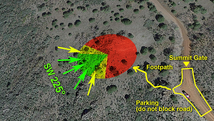
See image top of this page. There is ample, flat room below launch. Although the grass is short, it can cover basketball size rocks and boulders that can be dangerous. Try to land in a clearing or on or next to dirt road in zones marked in 1 (green) and 2 (yellow) on graphic map above. Advanced P4 landing area 3 (red) tends to have dirty air if the wind is out of the west or straight south so use caution. It's never worth trying to cut down your hike back to the campground area by landing the the red LZ area, though it is fairly safe if the wind is less than 5 mph.
The Wet Beaver Creek Canyon is very deep and steep. You do not want to land in our near it, and if you land south of it, you will have no way to hike back to launch but will have to be retrieved by car by a more-than-likely grumpy driver.
Be aware of local wildlife when landing (snakes, elk, etc.) as well as grazing cattle and the occasional bull embedded in the herd, following the dirt roads below launch to one of the many "tanks" (watering holes). In the warmer months, mosquitoes and "no-see-ums" (juniper gnats) can get aggressive at dusk, especially in light or no-wind conditions.
Do not overfly cars and spectators. Do not scratch, especially during thermic parts of the day. Obey ridge soaring rules as this can be a tight ridge with not a lot of room for traffic. Clear your turns!
Note: Pilots must familiarize themselves with this information before arriving, and this information does not replace the need for an in-person site briefing from a qualified, local pilot or instructor familiar with the area and experienced in flying the site.